SHALLOW WATER WRECKS- CONSUELO


FIVE DAYS OF HARD LABOR


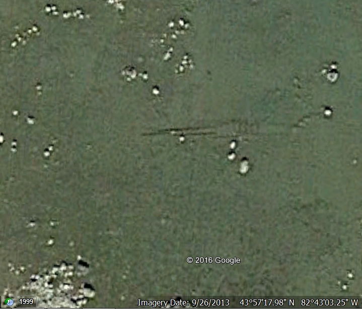
Some of these shallow water wrecks require a good deal of keen-eyed searching in order to find them. When you do it is often only by speculation that you can identify their remains. In the case of the CONSUELO, however, my search required neither of those. I had a few minutes of spare time (a very rare circumstance in my case) between my daily author tasks and picking my kids up at the school bus stop; about 7 minutes to be exact. Being a "creative ADHD" as they shrinks say, I just cannot let time waste away and so I decided to fire up my laptop, call up Google Earth and do some shallow water wreck scanning. I randomly picked an area just north of Port Hope, Michigan on the Lake Huron shore and setting my target on that area and setting the clock back 2013, I zoomed in. THIS is the screen-grab of what I saw as I zoomed in!

Of course it was surprising and exciting and of course I had just enough time to screen-grab and save the image. It would be a couple of days before I could research it. That job would be almost as easy.

Looking at my "list" of Port Hope wrecks I came across one that had a star... the schooner CONSUELO. When I went to my files of the annual reports of the U.S. Life-Saving service for the date of her loss I saw that not only was the whole story there, but I had drawn five stars in the margin and a chevron with the note "L.U." Two and a half decades ago, when I was compiling Xerox copies of the USLSS reports at the USNA's Nimitz Library in Annapolis I would carry a file for a given year along with me as I was commuting to my job as an airline pilot. On those long flights I'd read the reports and mark areas of interest. Two chevrons was my short hand for something good and "L.U." stood for "Look Up" meaning get the details of this vessel's history perhaps for use in a future book. Five stars meant "really good stuff."

(Take note of the big boulder sticking through the beams.)


Click HERE and make Wes
autograph and personalize
your book before he
sends it to you!


The wreck's keelson and beams are located just over 1,200 feet from shore and 8.26 miles north, northwest of the Sand Beach (now Harbor Beach) 1888 Life-Saving station. The two-masted schooner was 103 feet long and loaded with lumber from False Presque Isle to Detroit under the command of Captain Seeley. On the evening of November 9th, 1887 a southeast gale was blowing and the schooner was tacking against the wind. She had sprung a leak in the storm and while running for the safety of Port Hope found herself too close to the shore and the boulders as she ran aground. At 2 o'clock the following afternoon a telegram was sent from Port Hope to the Sand Beach life-savers stating that the vessel was in peril and that a steam tug had been summoned from Detroit to help free her. That tug would pick up the life-savers and their life-boat and tow them to the scene of the stranding. They arrived at 7:30 in the evening. It was decided that nothing could be done with the CONSUELO until daylight. Then, at 8:30 in the evening, the waves began to break over the boat and her crew of six grabbed their belongings and asked the life-savers row them to dry land. For the next four days the lifesavers worked at lightering her cargo of lumber in an effort to re-float her. It was no use as an inspection of her hull showed that a huge boulder was jutting through her bottom. All of her lumber was dumped overboard and collected by the life-savers and turned over to the owners. After five days of hard labor by the life-savers the CONSUELO was left to the lake which rapidly took her apart. Built in 1851, her old timbers were easy for Lake Huron to feast upon. The keeper of the Sand Beach life-saving station estimated that the wreck was "about 9 miles northwest of the station." That is almost exactly where these remains are located.

Yet there is another object...


In using Google Earth you can look carefully and spot this second object close to shore and 1,154 feet from the wreck site. 


Click HERE to get a book directly from Wes autographed and personalized


The object appears to be some sort of wreck piece, but without actually visiting the site and checking it out, it's impossible to say for sure that this is a part of a shipwreck. However, considering that the USLSS places the CONSUELO at this location, nearly exactly, I'd say we're pretty safe in saying that the remains out on the shoal is probably her- especially with the huge boulder stuck in her ribs.


SHALLOW WATER WRECKS: MONOHANSETT

MONOHANSETT'S FINAL RESTING PLACE 


Originally launched as the double decked freighter IRA H. OWEN in 1872 and later renamed MONOHANSETT on January 22nd 1882, this 160 foot long wooden steamer was a workhorse on a slim budget. Manned by a crew of only 12, which was legal in 1907, the boat was hauling coal when in the vicinity of Thunder Bay.


She suffered the fate of many a wooden vessel when she caught fire on November 23rd, 1907. Her captain managed to get her near Thunder Bay Island and the life-saving station before her crew abandon the vessel with nothing more than the cloths that they were wearing. No one was killed in the accident, although two of her crew suffered some minor burns.


The boat's remains rest today just off the southern tip of Thunder Bay Island in about 18 feet of water (depending on the seasonal level of Lake Huron).


She is a part of the Thunder Bay National Marine Sanctuary and can easily be seen on Google Earth.


Okay... so I go into a lot of detail. If, however, you like that sort of stuff take a look at  this book. Hey, it's just a suggestion... not like I'm huckstering... of course my kid just came back from the orthodontist and you can imagine the bill...


SHALLOW WATER WRECKS- BURNT CABIN POINT

THE BERLIN

BERLIN's remains on Burnt Cabin Shoal- Google Earth Image

While flying for the Michigan DNR on survey trips around Michigan's thumb I began to spot wrecks in the shallows along Lake Huron's shore. Eventually I took my camera along and photographed a few, but was never able to record the "exact" locations other than making some scribbles on my aeronautical chart. This one I found to be a real stunner. Now, 28 years after the DNR furloughed me, (Okay they said that I was still employed, but they simply were no longer flying the routes I was on... that way they didn't have to take the hit for un-employing someone. It was a furlough, no matter how you looked at it.), we have the wonder of Google Earth and by way of their latest high resolution satellite imagery and I've been able to locate several of my shallow water wrecks from my DNR days.

My 1988 photo of the BERLIN wreck.

In 1877 Captain A.M. Johnson was the owner and master of the 112 foot long wooden schooner BERLIN. The boat was his family small business and carrying whatever he could find as a paying cargo was how he fed his family. To economize the operation Captain Johnson had his son aboard functioning as a crewman. In f the first week of November, 1877 Captain Johnson had booked a cargo of limestone to be hauled from Marblehead, Ohio to Bay City, Michigan knowing full well that the weather would be rough, but that the profit from this cargo would likely help get his family through the long winter ahead when ice blocked the lakes and the sailing season came to an end. Unfortunately, on this trip, all that came to an end was Captain Johnson and the BERLIN. 

Click HERE and Wes will autograph and personalize your books


While attempting to round the upper tip of Michigan's thumb the BERLIN was running in a strong northeast blow with heavy rain. Her only source of navigation was the Point aux Barques (pronounced Aw- Bach) lighthouse which stood right next to the newly established US Life-Saving Station of the same name. Oddly, Point aux Barques itself is located nearly 8.8 miles, as the crow flies, and 10.1 sailing miles to the northwest of the lighthouse for which it is named. Captain Johnson managed to sail 8 miles beyond the light, but running in the pitch black of the November night he had gotten himself too far to the south of his course and ran aground on Burnt Cabin shoal, one of a series of rocky fangs that jut out from the thumb and look to spear any mariner who ventures too near.


Almost immediately the waves began to take the BERLIN apart as two of her masts fell and the seas shoved her along the shoal. Captain Johnson was one of the first to be washed over the side and parish in the bitter cold water. Next the ship's cook was washed overboard and as the captain's son was overcome with despair at losing his father to Lake Huron, the lake came and easily plucked him overboard to a frozen death. Of course Lake Huron could not let such a prize simply be swallowed- no indeed. Instead the waved entangled the Johnson boy's body in the fallen rigging of the vessel and displayed it there for the other three survivors to gaze upon and ponder own their fate.
Click HERE to buy Wes' books
and get them signed and personalized!


The original 1877 Point aux Barques life-saving station, now on display at Huron City, MI.- author's photo

Local residents discovered the wreck at daybreak and notified the Point aux Barques life-savers by telegraph. The wreck itself was well outside of the USLSS beach patrol area and was completely out of sight of the station's watch tower. Due to the distance and sea conditions the life-savers had to move their surfboat by horse and carriage in order to get to the wreck site and the trek took several hours. During that time, the ice water seas claimed a fourth crewman. By the time that the life-savers reached the wreck only part of the bow and one mast remained above the waves with two benumbed crewmen clinging to it. They were both rescued and the body of the captain's son was also recovered. The BERLIN herself was soon flattened by the winter ice, but small pieces of her occasionally come ashore to this day.

The entire thrilling story of the BERLIN can be found in this book of mine. BTW- I once saw Keepers of Valor being sold here for one PENNY! I had to buy that copy myself.


Keepers of Valor

SHALLOW WATER WRECKS: THE SCHOONER-BARGES MIDNIGHT & MEARS

I
THE MIDNIGHT AND MEARS


In 2016 Google Earth published some images of the lakes where the shoreline and shallow waters showed a great deal more detail than in previous publications. The above image is that of either the schoonerbarge MIDNIGHT or MEARS. The two were wrecked together on November 27th 1889 and have been scattering their pieces south of AuSable Point near Oscoda, Michigan ever since. Their story is detailed in my book, "True Tales of Ghosts and Gales" as in 2000 I was invited by Dr. John O'Shea, who has a cottage near the wreck site, to survey the wreck.


In 1999 I'd been asked to come to a fellow's cottage south of the wreck site where a large chunk of one of the vessel's beam ends had washed up near his dock. Yes, these pieces tend to travel. That find inspired me to research the the area and I uncovered the wrecks of the MIDNIGHT AND MEARS. So, when I visited the site with Dr. O'Shea, I already knew the whole story.


For generations local home owners have believed that the keelson was "just an old dock" and as we were surveying the site one lady came down to the beach and informed us that this was just an old dock. I asked her how she knew that? She said that he father had told her that. I then pointed out aspects of the wrecks site that showed otherwise and then told her the true story of the MIDNIGHT and MEARS. You could see her eyes turn from a look of dismissal to one of of wonder. Suddenly she went for casual observer to a protector of the site! No one was going to mess with these remains as long as she was residing nearby.


There is no way to actually tell exactly which of the two boats has left these bones as measurement is somewhat inconclusive.


Here's a great book on the study of wrecks along this shore

Much more of the wreck is hidden just beneath the sand and farther off shore. In fact some wreck-strippers from out of state began systematically stripping subsurface wood and transporting it across state lines in order to use it to make furniture. They were caught in the act in a soft-core sting conducted by the Michigan DNR and local law enforcement. Their operation was shut down in a very big way, property was reportedly seized and fins issued.


Of course pieces of the wreck that happen to wash up, "high and dry" can be lawfully collected. This piece, which may be from the wrecks, was used as decoration at a local resort.


Yet other pieces that come ashore are often dragged off by local residents who have no knowledge of the wrecks and burned in beach bonfires. Of course, you have to actually be able to lift them first.


SHALLOW WATER WRECKS: THE MARQUIS

THE MARQUIS- TOUGH ROCKS

Author's note: I first saw this wreck when I was flying for the Michigan DNR on lakeshore surveys of fishermen. The job was my first one in my aviation career and consisted of me flying a Cessna 152 at 1,000 feet and along the shoreline as the guy sitting next to me sat there with a clicker and counted people fishing below. In other words- I had nothing to do other than look down at the lake. When I spotted this wreck, I shouted "Just a minute!" to the counter-guy and banked sharply to go back and get a good look. "Wow! it's a shipwreck!" I exclaimed as we circled, oops... I was unaware that the guy siting next to me had never been in a 60 degree bank and a two-G turn before... he was white as a sheet.

Library of Congress collection
The Canadian Lock at Sault Saint Marie

With the vessel traffic on the Great Lakes booming and the need for Canadian vessels to transit between the lower lakes and Lake Superior, the government of Canada decided that they needed their own locks at the Soo. Of course the 1870 CHICORA "incident" helped the project more than anything as the British frigate, loaded with arms and troops bound for Hudson Bay, was denied passage through the American Soo locks for political reasons. When construction began in 1888 huge quantities of cut stone were needed. Those were cut in the southern part of Ontario and shipped by vessel up to the Canadian Soo. That activity turned into a cash boon for many a small vessel owner or operator. Captain Crawford of the three masted Canadian schooner MARQUIS was one such person who picked up some handy cash by hauling the cut stones for the locks. Although it took days to carefully load the cut blocks of stone at the Amherstburg, Ontario dock and the time needed to unload the stone at the Soo would take far longer, this load would likely cap off the 148 foot long schooner's 1892 sailing season. The value attached to the stone cargo was $8,000 and a good chunk of that would go into the the schooner's till as well as the captain's wallet. 


 While sailing up Lake Huron on the night of November 11th the MARQUIS encountered a classic late autumn gale with high winds and heavy snow. Although the storm as a true gagger, the boat was holding her own helped in great part by the stable and heavy cargo in her hold. Built in 1872, her hull was in good shape and she was doing well against the high seas. Unfortunately, Captain Crawford found that his boat had strayed from her course as her wooden keel suddenly felt the bite of the boulder-garnished bottom of Michigan's thumb. Immediately he knew that there was no way for him to get his boat off of the rocks and so he ordered he sea cocks opens had the schooner scuttled to prevent her from pounding herself to pieces on the bottom. It was a correct, but futile move as the waves quickly began to dismantle the schooner. She rests there today, just south of Hardwood Point in shallow water along with her entire cargo of cut stone.


 The lifesavers at the Sand Beach Station (now called Harbor Beach) were alerted to the wreck at four o'clock in the morning on November 12th and launched their lifeboat. The enlisted the aid of a steam tug to tow them the "four miles west, northwest of the station" to the wreck site. Three of the schooner's crew had gone ashore by way of the vessel's yawlboat, and it is likely that they were the ones who called for the lifesavers. The surf, however, was too high for them to return to the stranded wind-grabber and so the lifesavers used their lifeboat to shuttle the remaining four crewmen to the tugboat and then returned to the station. Meanwhile, as the days and weeks passed, Lake Huron simply chewed away at the MARQUIS until there was little left other than her bottom and lots of cut stone. The lost schooner's load was hardly missed and the Canadian locks opened in 1895.

SHALLOW WATER WRECKS: THE EUGENE

THOSE FORGOTTEN BONES ON PORT AUSTIN REEF
Basic scow-schooner.   Chicago Maritime Museum

Thanks to the high resolution imagery of the shore line of the Great Lakes taken in 2013 and released by Google Earth in 2016, we can now sit at home and scan the lakes for forgotten shipwrecks. This article will cover the wreck of a little scow-schooner that has been long forgotten- the EUGENE.

Built in 1865 at Fair Haven, Michigan, the EUGENE was just 64 feet long and only 16 feet in beam. Her flat bottom scow hull drew just 4 feet 4 inches of water meaning that she could operate in shallow backwaters where larger boats would normally go aground. On October 22nd, 1890 she was bound from Grindstone City , Michigan to Au Sable, Michigan with a cargo of oats in her hold and her deck stacked high with bales of hay when she was caught in a sudden gale and stripped of her sales and upper masts. Her captain raised a signal of distress as the crew simply waited for the wallowing and overloaded little scow-schooner to be consumed by mighty Lake Huron. Their luck, however, was not that bad as the big passenger steamer INDIA came hissing out of the storm and discovered the EUGENE some 25 miles north of Michigan's thumb. Pulling along side the EUGENE, the INDIA's crew opened a side port and rescued all of the EUGENE's people. No record exists as to how many were aboard the little scow-schooner, but normally it was a crew of between two and four people. The INDIA then resumed her course upbound to Sault Saint Marie where the castaways were put safely ashore.

Meanwhile, the little EUGENE just drifted with the storm until the winds swung around and blew her back toward land. She fetched up on the south end of a spit of land known as the Port Austin Reef. There the little laker broke up in the waves and was later ground to bits by the winter's ice. Today a scan of the Google Earth images shows pieces of her scattered along the reef. Her keel is jack-knifed in two pieces and a large section of her beam lays upon the bottom. There she rests totally forgotten... until now.


More information can be had HERE